
| ||||||||||||||||||||||||||||||||||||||||||||||||||||||||||||||||
| ||||||||||||||||||||||||||||||||||||||||||||||||||||||||||||||||
Weather Information for SE GA / SE SC
Pat's Forecast for SE GA / SE SC
Weather Discussion:
Tuesday, Jan 6
Beach Water Temperatures are in the middle 50s
Temperature & Precipitation Outlooks: 6-10 Days ... 8-14 Days Pat's 6 Week Weather Outlook
| ||||||||||||||||||||||||||||||||||||||||||||||||||||||||||||||||
|
Radar Views
Weather Satellite Views Move the mouse over the button to open the dropdown menu. Severe & Tropical Weather:  Severe Weather Outlook(Understanding The Severe Weather Outlook)
Excessive Raifall OutlookCurrent Severe Weather Watches from NOAARip Current RisksWinter Storm Severity IndexTropical Weather OutlookHurricane Winds ScaleSea Surface Temperature Severe Weather Outlook(Understanding The Severe Weather Outlook)
Excessive Raifall OutlookCurrent Severe Weather Watches from NOAARip Current RisksWinter Storm Severity IndexTropical Weather OutlookHurricane Winds ScaleSea Surface Temperature
Tides / Sun & Moon / Calculators: 
|

Data from the National Weather Service's
Selected Cities Weather Summary Past 24 Hour Temperatures in Savannah 
Click on graph for full size Local River and Tide Gauges
Coffee Bluff Weather Station
Coffee Bluff Weather Station Archives
Current Weather Reports in and around Savannah
Regional Weather Roundup
Current METAR Reports
Current Savannah Airport Report
Air Quality Index
Recent Astro Views: 


... Click on any picture for a full view ... 
 Asbury Memorial Church ... Asbury Memorial Church ...
| |||||||||||||||||||||||||||||||||||||||||||||||||||||||||||||||


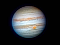 ... A view of the planet Jupiter from the Heavenly Backyard


Looking for a hosting service for your web page? A2 Hosting would be a good choice
Back to the Top of the Page
 Send our comments to Patrick Prokop ... patprokop49@gmail.com
Visitors to this page: ...